Hydrographic Surveying
We have been surveying the waters in North America since 1998. Our main and original purpose was to fill the holes that exists in the NOAA bathymetric database. This was the data we used to create our 3D bathymetric charts called Contour. Then in the winter of 2000, ESPN hired us to survey the lakes that were used by BASS tournaments and the Great Outdoor Games. We were asked to collect the data for the purpose of showing a 3D model of the sea floor of the lakes so the shows commentators could better explain where the fishermen were fishing, and why that spot was productive. Over the years, have conducted hydrographic surveys for the History and Discovery channels as well as BP and Exxon. Locally we have been performing hydrographic surveys for dredging jobs and locating and monitoring oyster bars.
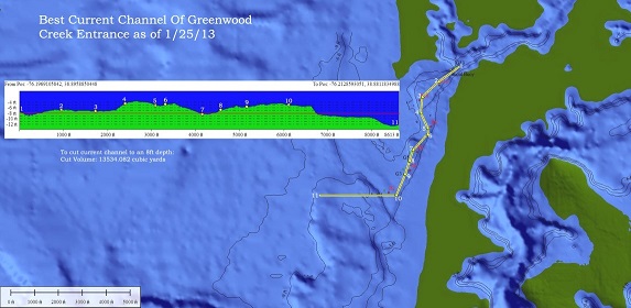
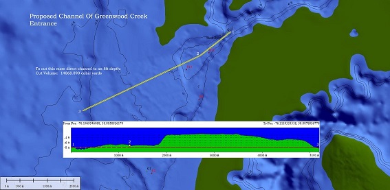
We are able to survey an area to determine the most efficient path to dredge a channel and tell how much spoilage would need to be removed to create a consistent minimum safe depth at a certain width.
We can survey a channel for maintenance dredging. Channels dredged long ago will require maintenance dredging to ensure it does not fill in. We can survey the channel and make a 3D rendering and evaluate what areas need attention as well as determine how much spoilage would need to be removed.
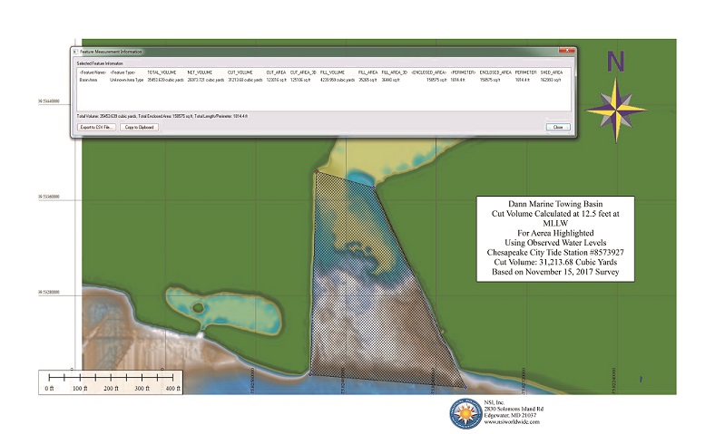
We have also surveyed marina basins to make sure they stay at a certain safe water depth. If dredging is needed we can estimate exactly where the dredging needs to occur and how much spoilage would need to be removed.
Our Equipment
We have our own survey vessel. It was built for us by Palmer Boats located in the Pacific Northwest. It is a 26 Defiance with twin Suzuki outboards. This is a great survey platform as it can perform in very shallow water. It is equipped with the latest sonar technology. Built into the hull of the vessel are three Airmar retractable multi-beam transducers each at a different frequency. This data is fed into Sea Bat where it is collected and merged with GPS position and time. We use a WAAS enabled 46 parallel channel GPS which provides us accuracy within 1 meter. We also have 2 Simrad sonar systems that record down and side scanning images. These units allow to provide photo like quality images of the sea floor as well as show hardness of the bottom.
We can take care of all the permit work and present the hydrographic survey to interested parties as well as estimate the dredging project itself. Furthermore, we can quality control the dredging project to make sure the dredging contractor has fulfilled the contract requirements.
|